|
|
|
|
 |
||
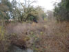
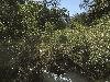
Napa River

| Image Data | |||
| Date: Direction: State: Country: Marker ID: |
12/13/2009 South East California USA 81 |
||
| Location: | Silverado Road and Lodi Road north of St. Helena | ||
|
|
|
|
Association: Scientist
Longitude: -122.490558
Description: Palustrine scrub-shrub covering the small channel area of the Napa River between the stream banks. The channel is completely flooded in the spring and winter.
 12/13/2009 |
 03/30/2016 |