|
|
|
|
 |
||
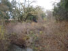
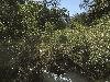
Napa River

| Image Data | |||
| Date: Direction: State: Country: Marker ID: |
03/30/2016 South East California USA 81 |
||
| Location: | Silverado Road and Lodi Road north of St. Helena | ||
|
|
|
|
Association: Scientist
Longitude: -122.491014
Description: Scrub-shrub wetlands on gravel bars in stream channel have grown in height and density. Water level has been higher in channel recently.
 12/13/2009 |
 03/30/2016 |