|
|
|
|
 |
||
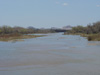
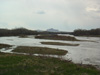
North Platte River

| Image Data | |||
| Date: Direction: State: Country: Marker ID: |
04/30/2005 West Nebraska USA 149 |
||
| Location: | US 26 bridge at Bayard | ||
|
|
|
|
Association: Government
Longitude: -103.325837
Description: Riverine channel with spring flow reduced. Sandbars more visible at lower flow with vegetation present.
 04/26/2004 |
 04/30/2005 |